Just when you thought you would not have to hear any more about Hurricane Irene, along comes my blog about it. Mercifully, this blog is brief. I was impressed with the non-stop, comprehensive coverage provided by the Weather Channel and other national and local broadcasters as this record storm made its way up the East Coast of the United States. What an extraordinary example of how today's technology benefits our lives. Imagine a storm of this intensity a hundred years ago - fatalities would probably have been many many thousands of people. For us today though, having reporters on site providing observations, having real-time access to satellite and ground radar images - these are benefits that have remarkably improved our lives and safety.
The beauty of this sunrise belies the cause - this is the approaching edge of the outermost cloud bands associated with Hurricane Irene.
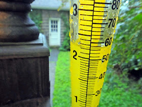
A few hours worth of rainfall in our yard - we ended up with 3 1/2 inches total - not that much compared to many past rainstorms or other locations in the path of this storm.
Imagine the value of this information a hundred years ago to a sailor or shipper or farmer or builder trying to make plans - we take this technology for granted and EXPECT it to be available to us all the time.
Damage-wise from the storm, we were fortunate in that only some high branches from tall maple trees snapped off and fell on our power lines and back deck railings.


No comments:
Post a Comment